Confirm the parcel and zone
The address resolves to lot 71RP148686, a 759 m² lot in the LDR zone. That establishes the base planning framework, not the development answer.
Worked example · The Gap QLD · sample dated 17 July 2026
This walkthrough uses the current 21-page sample to show why planning screening is not a single red-or-green answer: different overlays identify different constraints, evidence and follow-up questions.
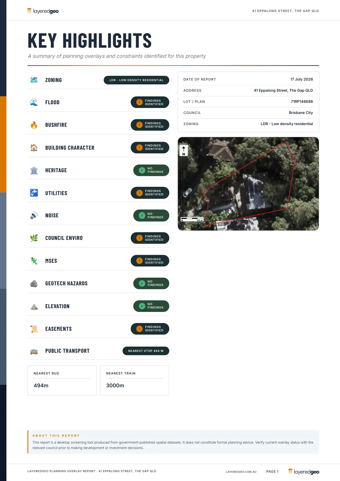
Before relying on a development concept or property assumption, which mapped planning and infrastructure constraints intersect this 759 m² residential lot - and which apparent “no finding” results need to be read alongside other datasets?
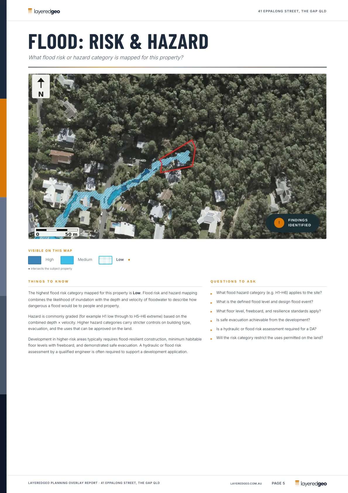
The key interpretation lesson
The report finds no planning-scheme flood overlay and no mapped overland-flow path. A separate flood risk and hazard layer, however, maps the property in a low category.
That is not a contradiction. The scheme overlay asks whether regulatory flood provisions are mapped; the risk layer asks what hazard category is represented in another source. The worked example keeps both results visible so the next enquiry is based on the whole evidence set.
These findings are transcribed from the sample report and should be verified against current authority records before a decision is made.
| Screening question | Sample result | What to check next |
|---|---|---|
| Planning zone | LDR Low density residential under the Brisbane City planning scheme | Confirm the intended use, assessment pathway, applicable zone code, height, setbacks and site cover. |
| Flood | No scheme overlayLow risk category No overland-flow or mapped historical-event finding | Confirm current council flood information, defined levels and whether site-specific hydraulic advice is required. |
| Bushfire | Finding High hazard buffer area | Establish whether a BAL assessment and bushfire-responsive siting or construction are required. |
| Building character | Finding Traditional building character overlay | Review demolition, alteration, streetscape and character-code implications for the proposal. |
| Utilities | Finding Stormwater main crosses the property; water and electricity mains mapped nearby | Obtain current service plans, locate assets physically and check access, protection and building-clearance requirements. |
| Environmental mapping | Finding Council biodiversity area plus four mapped MSES habitat or vegetation categories | Check ecological assessment, vegetation-clearing and referral implications against the development footprint. |
| Easements | One cadastral easement Easement lot A on RP148686 | Read the registered plan and current title to confirm purpose, beneficiary, terms and exact constraints. |
| Other screens | No finding Heritage, noise, geotechnical/natural hazards and elevation constraint screens | Treat each result as source-specific; confirm any issue material to the proposal through the relevant authority or specialist. |
The address resolves to lot 71RP148686, a 759 m² lot in the LDR zone. That establishes the base planning framework, not the development answer.
Flood regulation, flood risk, bushfire, character, environment, services and easements are kept separate because each dataset has a different purpose and consequence.
The report directs attention to BAL assessment, character controls, utility clearance, ecological review and registered easement documents rather than leaving a list of map names unexplained.
Council planning maps and codes, title documents, service plans and specialist advice then confirm what applies to the actual proposal and development footprint.
Enter a QLD, NSW, VIC, SA, TAS or ACT address for a free map preview, then generate the full PDF when you need the evidence together.
Check an address →